Ship Routes and Timelines
THE WORLD AT WAR IN 1941
Before showing the ship routes, it’s important to know the situation in the world and where the Zamzam, Atlantis, Dresden, and HMS Devonshire were in relation to each other. Here’s a quick summary of the world at large. Note that the map is not to scale.

Map 1. World Politics of 1941
NORTH AMERICA
Canada had declared war on Germany on September 9, 1939, after Hitler invaded Poland (on September 1, 1939). They trained and fought alongside the Allies to the end of the war in 1945.
The United States was neutral and not at war at the time of the sinking of the Zamzam. Humanitarian organizations like the British-American Ambulance Corps (BAAC) trained medical personnel, provided medical supplies, and sent them to hot spots around the world. On March 11, 1941, the Lend-Lease Act was passed and provided U.S. military aid to foreign nations already at war with either Germany or Japan with the expectation of being repaid post-war. This allowed President Franklin Roosevelt the ability to legally aid Britain after the sinking of the Zamzam and indirectly help in the Battle of the Atlantic. The United States and Britain declared war on Japan on December 8, 1941, the day after the Japanese attacked Pearl Harbor, HI.
Mexico did not support Germany in the war effort. At a conference in Rio de Janeiro of Latin American foreign ministers in January of 1942, the Mexican delegation convinced many other countries to follow suit and break ties with the Axis powers. After German submarines began attacking Mexican merchant ships and oil tankers, Mexico formally declared war on the Axis powers in May of 1942. The Mexican navy began actively engaging German vessels and Axis spies in the country were rounded up and arrested. Mexico began to plan to actively join in combat, sending troops to the European Theater.
SOUTH AMERICA
The members of the Pan American Union, who were all neutral between 1939 and 1941, formed a mutual defense pact in Havana, Cuba. The “Declaration on Reciprocal Assistance and Cooperation for the Defense of the Nations of the Americas” was signed on July 30, 1940. This union included the United States, Brazil, Chile, Columbia, Costa Rica, Cuba, Dominican Republic, Ecuador, El Salvador, Guatemala, Haiti, Honduras, Mexico, Nicaragua, Panama, and Venezuela.
Strategically, Panama was the most important Latin American nation for the Allies because of the Panama Canal (completed in 1914), which provided a link between the Atlantic and Pacific Oceans that was vital to both commerce and defense. Brazil was also of great importance because it is the closest point in the Americas to Africa where the Allies were actively engaged in fighting the Germans and Italians. For the Axis, the Southern Cone nations of Argentina and Chile were important resources. German supply ships, including the Dresden, often obtained cargo from Brazil, Argentina, and Chile during the Battle of the Atlantic from 1939 to 1945.
However, starting in 1942 with increased war activity off its coastline, Brazil participated in patrolling and anti-submarine warfare in the South and Central Atlantic, in part funded by the US Lend-Lease Act. Brazil then provided a ferry point for the transfer of American-made war materials to the Allies fighting in North Africa. In July 1944, Brazil sent an expeditionary force to support the Allied Italian campaign. Brazil and Mexico were the only countries to send troops to the European Theater.
EUROPE
In 1941, Europe had been at war for nearly three years.
As Adolf Hitler became Chancellor of Germany on January 30, 1933, plans for the Third Reich were initiated. By the end of 1933, Oranienburg and Dachau concentration camps had opened and the book burning campaign had begun. In 1934, Adolf Hitler was Fuhrer of Germany, Austrian Chancellor Dollfuss had been murdered by the Nazi regime, the Treaty of Versailles had been violated by Germany, and the Nuremberg Race Law was in effect, stripping German Jews of all human rights, soon to be followed by the euthanizing of the sick and disabled. By 1936, the German Gestapo was placed “above the law”, Mussolini had invaded Ethiopia, then civil war broke out in Spain and Francisco Franco would begin his 39-year reign of the Spanish State. Franco would maintain control of Spain, as Hitler invaded the Soviet Union in the summer of 1941 instead of continuing south to conquer Spain and Gibraltar. Maintaining the Russian Front would drain German resources and Spain was never invaded but still had a Nazi presence in some regions.
Britain, France, Australia and New Zealand declared war on Germany on September 3, 1939, after the invasion of Poland. The British Blockade, or Blockade of Germany or Economic War, started in 1939 and lasted to the end of the war. Initiated by the United Kingdom and France, its purpose was to restrict the supplies of minerals, metals, food and textiles needed by Germany and Italy to interfere with their war efforts. This was implemented via a naval blockade, which formed part of the Battle of the Atlantic, and included buying materials from neutral countries to prevent their sale to the enemies. Germany and Italy launched a counter blockade which included the raider Atlantis continually attacking and disrupting Allied naval supply lines. By 1940, Britain occupied Syria and Lebanon, and was defending British Somaliland against the Italians as the battle for Africa began.
The Tripartite (Axis) Pact was signed by Germany, Italy and Japan on September 27, 1940.
By March 1941 when the Zamzam left New York, and the list of countries under Axis occupation was a long one. As summarized on Map 1, it included Czechoslovakia, Ethiopia, Austria, Poland, Denmark, Norway, Belgium, The Netherlands (Holland), France, Egypt, Romania, Hungary, Libya, the Channel Islands, British Somaliland, Luxembourg, Greece, Yugoslavia, Finland, Ukraine, Estonia, and Belarus. Tunisia was under attack and a pro-Axis regime was active in Iraq. Note that Romania, Poland, Lithuania, Latvia, Estonia, Belarus, Ukraine, and Finland were both German and Soviet “spheres of influence” up until June 1941. Andorra, Ireland, Portugal, Spain, Sweden, Switzerland (with Liechtenstein), and The Vatican were neutral.
THE SOVIET UNION
Joseph Stalin rose to power after Lenin’s death in 1924. The country had been devastated by the famine of the early 1930s, then Stalin supported the anti-fascist movement during the Spanish Civil War, and communism and his Politburo were firmly established by 1936. Prompted by Germany’s annexation of Austria and Czechoslovakia in 1938, the Soviet Union signed a non-aggression pact with Germany in August 1939, resulting in the joint invasion of Poland. But on June 22, 1941, Germany invaded the Soviet Union, initiating the war on the Eastern Front as part of Operation Barbarossa. Stalin then allied himself with the United States and Britain.
The Soviets helped bring about the end of the war in Europe by launching the Battle for Berlin. On 20 April 1945, Hitler’s 56th birthday, Soviet artillery began shelling Berlin and did not stop until the city surrendered. Hitler committed suicide in Berlin on April 30, 1945. On May 3, part of the German army surrendered to the US Army and on May 9, 1945, another part of the German army surrendered to the Soviets.
THE FAR EAST
Japan had already been at war in Manchuria since 1931 and with China since 1937. Japan had occupied Korea prior to World War I (since 1910), and uprisings in Korea during this new war caused issues for the Japanese government. On September 27, 1940, Japan signed the Tripartite Pact signed with Germany and Italy, formally forming the Axis powers.
By 1941, Japanese military expansion in the Asia-Pacific region was significant and increasingly a threat to the United States. French Indochina (Laos, Cambodia, Viet Nam) were occupied by the Japanese through an agreement with the Nazi-supported Vichy regime in France. By the end of 1941, Japan would invade Thailand, Kiribati, Wake Island, and New Guinea (Papua New Guinea today).
Immediately after the attack on Pearl Harbor, the United States and Britain declared war on Japan on December 8, 1941. Map 1 shows Japan’s occupation of Korea, Manchuria (1931), as well as occupations of Beijing, Shanghai, Nanjing, and Wuhan (1937) on the mainland in direct conflict with China. In the Pacific early in 1941, Japan began the invasion of the Philippines and the surrounding islands. By October 1942, they would invade the Philippines, Indonesia, Singapore, Burma (Myanmar today), East Timor, Guam, Nauru, Attu Island, and Kiska Island (off Alaska). Because of their strategic value in the Pacific, the Philippines would be the center of conflict until the end of World War II in 1945.
THE SHIP ROUTES AND TIMELINES
The four key ships involved in the Zamzam saga would cross each other’s paths several times before the Zamzam incident. Both the equator and prime meridian are shown on the maps. Also refer to the Ship Histories webpage for more information. Note that the maps are not to scale. These ships are:
The Zamzam
Map 2 shows the route the Zamzam took from New York City, NY, to South America, to the middle of the Atlantic Ocean where it was sunk by the Atlantis at 27.41S;08.08W. The planned path is also shown, depicting the intended route from Recife, Brazil, to Cape Town, South Africa, up the coast of Madagascar to Mombasa, Kenya. Most of the missionaries and business men would have disembarked by Mombasa, taking land transportation to their final destination in the interior. Some passengers, like the British-American Ambulance Corps (BAAC), had intended to continue to the home port of Alexandria, Egypt. The path the passengers ended up taking aboard the Dresden from the middle of the Atlantic to occupied France at St. Jean de Luz is shown on the map.
The final route home for most of the Americans on board the Zamzam was from St. Jean de Luz to Biarritz, France, through Spain to Lisbon, Portugal. From Lisbon, either by air or sea, they returned home to the port of origin, New York City, NY (also shown on the map). The Germans would not allow any of them to continue on to Africa. The other passengers, as well as several Americans the Gestapo would not release, were transported from St. Jean de Luz and Biarritz, France, to camps in occupied Axis countries. This included French, German, Polish, and Yugoslavian Nazi camps. Also refer to the Ship Histories webpage for more information.

Map 2. Route of the Zamzam and its Passengers in 1941
The Atlantis (Tamesis)
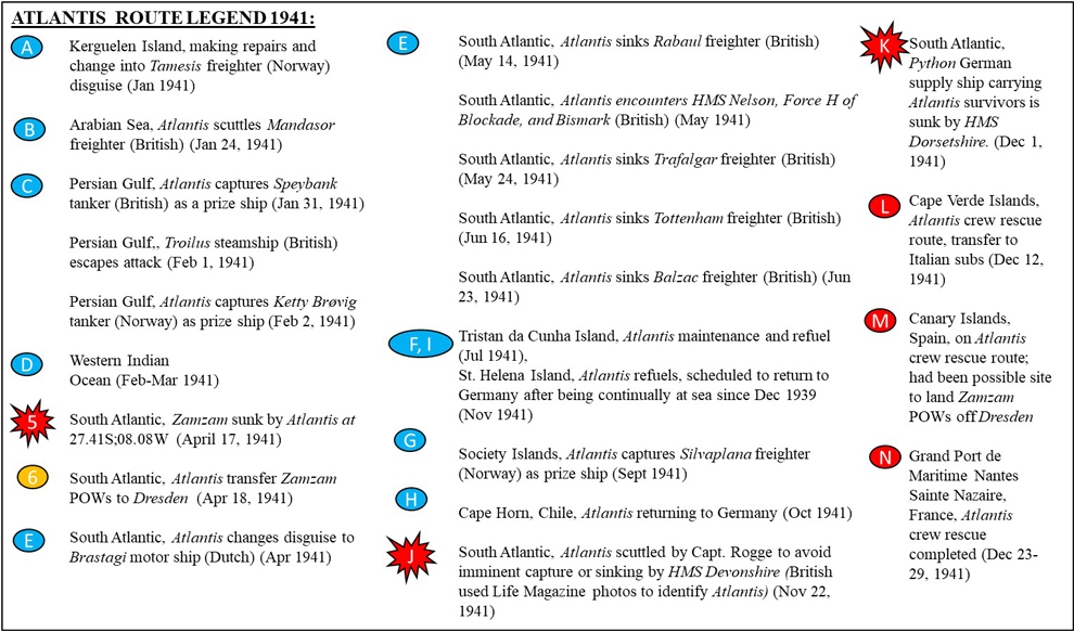
As shown on the map, the U-126 took the lifeboats from Atlantis in tow until the German supply ship Python could take the crew and Zamzam prisoner Frank Vicovari (an ambulance man who was still in sick bay) on board. On December 1, 1941, the Python was in turn located by the British cruiser HMS Dorsetshire and again Atlantis’ crew had to head for the lifeboats, and again they were taken in tow, heading north. Their escape route passed by the Cape Verde where Italian submarines, including the Luigi Torelli, took on some of the crew. They also passed by the Canary Islands (Spain), which had been considered earlier that month as a possible landing port for the Zamzam prisoners but was shelved in favor of an occupied territory. After having been towed more than 5000 miles Rogge and the last of his crew finally reached occupied France at Grand Port de Maritime Nantes Saint-Nazaire on December 29, 1941. Also refer to the Ship Histories webpage for more information.


Map 3. Atlantis (German) Route during the Battle of the Atlantic in 1941
The Dresden
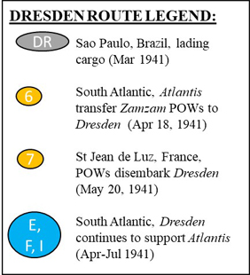
The Dresden sailed the breadth and width of the ocean, often obtaining goods from Brazil, Chile, Argentina, or islands and territories owned by these South American countries. Its route zigzagged back and forth in the South Atlantic Ocean from 1939 to 1945, meeting with its target ships at predesignated locations far from the main shipping lanes (e.g., along the Brazilian coast) or areas of heavy activity with the British Blockade. The ship supported multiple German battleships, including the raider Atlantis and its sister raider the Pinguin. The complex supply routes are not shown due to the scale of the maps presented here. The Dresden route on Map 4 depicts where it was involved in meeting the Atlantis for resupplying and the transfer of the Zamzam prisoners from April to May 1941. It also depicts the route taken north to occupied France at St. Jean de Luz, where the Zamzam prisoners disembarked and were taken prisoner by the Gestapo. The Dresden would undergo repairs and be sent back out to the Atlantic to continue providing supply services for the German Navy. Also refer to the Ship Histories webpage for more information.


Map 4. Dresden (German) during the Battle of the Atlantic in 1941
HMS Devonshire
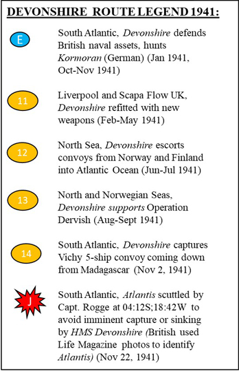
The Devonshire was active in providing escort and protection services for ships in the British Fleet. This included providing coverage for convoys to/from the Soviet Union and to Africa, as shown on Map 5. During 1941, her activity included the full length of the Atlantic Ocean, from the farthest north (and beyond to the Norwegian and North Seas) to the farthest south.
While completing a mission off the coast of Madagascar, the Devonshire received a suspicious message which was confirmed to be falsely sent by the SS Polythemus. The message had indeed been sent by the Atlantis as a ruse. After confirming with the commander in chief of the Combined Fleet that the message could not have come from the SS Polythemus, the Devonshire was alerted to raiders in the area and tracked the Atlantis, attacking and partially sinking it while the Atlantis was in the process of refueling with the German submarine, U-Boat 126 (U-126). Upon detecting U-126, the Devonshire retreated and Capt. Bernhard Rogge scuttled his own doomed ship so that it would escape enemy capture. As a defensive ship, the only ship the Devonshire ever purposely attacked with the intent of total destruction was the then infamous Atlantis. The Devonshire continued escorting convoys in the Atlantic and then returned to Scapa Flow, Scotland, to support the Home Fleet later in the war. Also refer to the Ship Histories webpage for more information.


Map 5. HMS Devonshire (British) during the Battle of the Atlantic in 1941
Combined Map of the War and All Ships
Map 6 shows the overlay of Maps 1 through 5. Also refer to the Ship Histories webpage for more information.

Map 6. Combined War and Ship Route Map (see map legends from Maps 1-5)
